|
NOTES:
This map is the work of antiquary
John Speed (working with the
Dutch engraver Hondius) and was created as an inset for a map of Suffolk
published in 1610 as part of a series of county maps. (The additions in
colour are of course my own).
|
| |
DEFENCES
|
| |
Line of the ditch/wall
The line (which I have indicated by a brown overlay on Speed's map) was
clearly suggested in the topography of the streets into the 19th century
(although less so with late 20th-century redevelopment), including street
names like Tower Ditches and St. Margaret Ditches. According to a note in
one of the Ipswich Domesday Books, the ditches were dug in 1203; but
this does not rule out the effort simply being an enlargement or extension
of an earlier line of defence. There are fairly frequent references to
grants of parcels of the town ditch, particular along the northern
boundary, where they are sometimes referred to as the "great ditches of
the town". Walls are far less commonly mentioned and their extent is
uncertain. In 1302 a burgess was granted a lease of part of the
ditches, for 6d. a year, to be voided if the town were ever enclosed by
a wall. We hear of town wall in St. Margaret's parish in a grant
of 1315, and in St. Mary Elms parish in 1323. A change had occurred
between the compilation of a custumal in
1291 and its translation into English in the fifteenth century, since
the former refers to a watercourse called "Botflood" (the flooded town
ditch?) passing along the side of a road, while the latter refers to it
running alongside the wall. What wall-building there was may have
focused on areas where the ditches were weakest and may never have
proceeded to creation of a continuous line; the eastern and western sides
of the borough clearly had walls, but it is less certain that the
northern perimeter did.
|
| A |
North Gate
No.4 in Speed's key, where it is named Old Bar Gate. The road from here
led towards Norfolk.
|
| B |
West Gate
No. 3 in Speed's key, where it is named Barre Gate. The same name
(portas barratas) is found in a deed of 1343, in which the town
authorities rented to Robert le Loyker a plot of land just north-east
of the gate, where the town wall north of the gate began to curve
eastwards; they reserved right of access to the wall for purposes of
repair or defence. The gate's position at one end of the main street
running through the town reflects its importance. Part of it was
converted into a town gaol in the early 15th century, and was rebuilt to
be more suitable for that purpose in 1449 at the expense of burgess
John Caldwell. The road from here led deeper into Suffolk.
|
| C |
Possible site of the castle
The location of the relatively short-lived Norman castle is unknown.
Some have argued that it lay outside the town defensive perimeter, to
the north of Christ Church (and therefore off Speed's map), or just
within the northern perimeter where the ditch could have served as
part of the bailey ditch. The basis of these theories seems to be
topographical: names (some post-medieval) such as St. Mary Tower, Castle
Hill (a feature well north of the town), and the Tower Ramparts on the
line of the northern defensive perimeter. However, it seems likely that
a castle intended to overawe the citizenry would have been conspicuously
placed and reasonably close to the town centre (as at
Norwich), or at least on the edge of
town – not as far away as Castle Hill. Speed has on his map a feature
that is not identified, yet clearly of some significance: immediately
west of Cornhill a walled precinct fronted by sturdy wall with gate and
towers (later part of a sizable residential complex). Might this have
been part of the castle bailey? The curving line of Elm Street is
suggestive of a route skirting a bailey, while the presence of St. Mary
Elms is not necessarily a problem, since one of the three St. Mary's
appears not to have existed at the time of Domesday, and St. Mary Elms is
the likeliest canadidate. Furthermore, the archaeology of Cornhill,
suggesting Norman attention to redevelopment there, to enhance its market role,
also tends to support the idea that a seigneurial base could have been close by.
By contrast a location just south of the northern ditch, incorporating the ditch
into its defences, could be
expected to have left some mark on the line of the ditch, but no anomaly
is evident. By Speed's time the grounds here suggested as the possible
bailey site were apparently being used for an orchard. The absence of
houses from a large stretch there of what was essentially the town's
high street is apparent and otherwise difficult to explain. A location
atop the slope leading away from the river, and not far from the central
market, is plausible enough; the location proposed here would have
commanded access to the river crossings at Handford (west) and Stoke
(south). A Shirehouse Hill is heard of frequently in the 15th century,
when parcels of land there were being leased to private citizens, and
as early as 1309 – this is doubtless connected with the site of the
county court, for which a new building was constructed in 1397; its
location, downslope near the quayside, would not be strategically as
desirable for a castle, and it is doubtful the "hill" would have been
the old mound for a keep. The relatively early
disappearance of the castle, in 1176,
may explain why there seems to be no memory of its site in topographical
names; although there is reference in 1486 to a plot of land in Ipswich
called "Erlebegotes" (Earl Bigot's), the location is not identified and
it might have been buildings the earl is said to have owned at the
quayside.
|
| D |
Other gates
The routes of streets strongly suggest the location of gates (or at
least routes across the ditch) here, although no trace of their names
remains on historical maps; they were probably lesser gates than the
those marking the entrance into the town of the crossroads that was the
early focus for settlement. The Ipswich Domesday book, in regulating
fees for the carriage of merchandize, makes reference to sacks of wool
passing through the East Gate, North Gate and West Gate. The
topography of the town suggests that the likeliest location of the East
Gate would have been at the end of Carr Street. There may also have
been a gate further south, midway along the eastern stretch of ditch/wall,
although neither the road approaching this point from within the town,
nor the road leading directly east out of the town were of major
importance, and we would expect any gate there to have been mentioned
in the 14th-century description of the four wards of the borough (since
the boundary of two of the wards passed through that point). Roads
heading eastwards from the town led to the Suffolk coast. A Bull Gate
is shown on Speed's map in the northern stretch of the defences, but its
proximity to the West Gate and the fact that the gate leads only into
fields (there was no road beyond it) show it as of minor significance.
|
| |
COMMUNITY SPACES, STREETS AND
STRUCTURES
|
| E |
Common meadow and marsh
A large area of somewhat marshy ground west of the Gipping belonged to
the burgesses in common; the northern part in particular, being drier,
was used for pasturage. The common meadow included Portman Meadow,
dedicated in 1200 to pasturing the
horses of the town councillors; before 1200 and through the 14th century
it was known as Odenholm meadow, although by the 1440s it was being
called Portman's Meadow. It was accessed via a ford and later by Friars
Bridge.
|
| F |
Thingstead
This was a roughly triangular area of ground just east of North Gate; in
1315 it was itself referred to as a highway. A meeting-place of roads,
even though its centre was built on by Speed's time, this large open
area was still described in later times as a "green", a term itself
suggesting a meeting-place of people. The name implies it an early
location for the folkmoot, although we
cannot be sure whether this might have been a burhgemoot or a
shire-moot serving not just Ipswich but other hundreds of east Suffolk.
The fact of it being in the populous parish of Holy Trinity – usually
a dedication of some importance – supports the possibility of a folkmoot
located here; although by 1200 (when, and perhaps because, Holy Trinity
had become a priory and was subsequently superseded by St. Margaret's)
the community meeting-place had apparently shifted to St. Mary Tower.
The parish is occasionally referred to as St. Margaret in Thingstead,
which may suggest that the churchyard absorbed some of the land
previously used for the folkmoot.
|
| G |
Westgate Street/Tavern Street/Carr Street
This set of streets, essentially one east-west high street through
the town, running along the ridge atop the slope leading down to the
riverside, appears to have been the basis for the foundation of the
settlement, and the focus for initial habitation in the 7th century.
Westgate Street, leading from the gate to the town centre at Cornhill,
was not often referred to by name in the Middle Ages; but when it was we
find the name Burgate Street at first, and later Barregate Street. It
is not certain whether the street name derives from "burh" (which would
reinforce the early significance of this highway) or from the barred
gate at the west end. In the early 14th century Carisshstrete was
the name for the eastern part of this highway, and perhaps the central
part too (there seems to be no medieval foundation for Tavern Street).
|
| H |
Cornhill
No. 8 in Speed's key. As the name indicates, the focus of the grain market.
The town centre, where one of the most ancient town churches stood and also
the location of the moothall/tolhouse and
later the hall of Corpus Christi gild (successor to the Merchant Gild).
Archaeological investigation on the site has indicated surfacing of the area
by the Normans, apparently obliterating some residences (indicated by pits and
post-holes), in the process, though this does not preclude the area having been
an unsurfaced Saxon market.
|
| I |
Friar's Bridge
The name suggests it may have been built contemporary with or shortly after
the establishment of the Franciscan friary (although it might have had a
different name earlier). The only evident purpose of the bridge was to
provide access to the community pasturage on the far side of the Gipping.
|
| J |
Brook Street
No. 9 in Speed's key, Brook Street was the principal north-south route
through the town, connecting the main east-west route with the western
end of the quayside. This role would have made it an early feature of
the settlement. It has been hypothesised that the name of this street
derives from the watercourse that ran down its centre (a feature
supportive of early settlement). However, the name is more likely
associated with being a route to the neighbouring manor of Brooks to the
north; some medieval spellings of the name (Brokesstrete) support this.
|
| K |
The Quay
S in Speed's key. Archaeological evidence seems to indicate that a
quayside revetted in timber existed from the Middle Saxon period.
Successive phases of timber and wattle revetting are evidenced, as
there took place gradual reclamation of land from what was once river.
It may have been the case that, when built, the churches of St. Peter
and St. Mary Quay stood close to the riverbank; archaeological evidence
from the quayside area shown on Speed's map is largely late medieval.
The quay proper, from
where the borough porters transported landed goods to the marketplaces
or merchants' warehouses, stood immediately outside the defensive
perimeter of the town. In 1306 Roger Bigod, Earl of Norfolk, died
seised of the quay and the houses there. By 1398 it seems to have been
in the hands of the king. By the 15th century the quay was outfitted
with a crane and a public latrine.
|
| L |
Customs house
Speed shows two structures on the quayside, neither identified in his
key. One is clearly a crane. This was in existence by 1454, when borough
authorities required that all outsiders bringing merchandise to Ipswich
for sale have their goods weighed by the crane; but there were probably a
series of cranes on the quayside: repairs to the crane was an item in the
1446/47 chamberlains' accounts, and a replacement had to be built in 1477.
The other structure, judging by its location, might well be the precursor
to the later Customs House. In 1433 a grant of land referred to the
nearby "Houses of Office" on the quay. One of these may have been the
Woolhouse which in 1448 was specified by borough authorities as the only
place at which wool might be bought and sold, and which in 1451 was
farmed out (along with collection of customs at the quay and the
fleshhouse, operation of the weighing beam, and other sources of
revenue) to John Bole.
|
| M |
Stoke Bridge
Q in Speed's key. A bridge across the Orwell connecting Ipswich with
the hamlet of Stoke (part of which was held from ca.970 as a liberty by
the Abbey of St. Etheldreda, Ely), where many burgesses had fields
and other property. The bridge was certainly in existence in the late 13th
century: in 1301 the will of Thomas Aylred assigned an annual rent towards
the maintenance of the bridge, to be administered by the bridge's
custodian – this not so much charity as gratitude, reflecting the fact
that Thomas, as a holder of property in both Ipswich and Stoke, must
personally have benefited from the existence of the bridge. However,
the fact that Saxon Ipswich ware has been found in Stoke and the mention
in Domesday of at least one, if not both, of Stoke's parish churches,
creates the suspicion that some kind of crossing facility would have
existed far earlier. In the 1430s John Caldwell offered to renovate
the bridge at his own expense if townsmen would contribute to the
maintenance. Access into the town via the bridge was protected by some
kind of barrier by the 15th century, for an ordinance of 1477 placed
the keys to the bridge in the custody of the bailiffs. Possibly the
"Peter's Bridge" towards whose maintenance the borough assigned, in 1378,
the rent from a tenement, it was also referred to on occasion as Ipswich
Bridge and Port Bridge. By the 15th century, it appears to have
been perceived as two separate bridges, the one closest to Ipswich
called North Bridge and that closest to Stoke being called Stoke Bridge;
the reason for this is not evident from Speed's map but relates to a
peninsula (created by a watercourse lying between the Gipping and Orwell)
which provided a midway foundation for the linkage between Ipswich and
Stoke. In the 19th century the intermediary watercourse was filled in
and the northern part of the bridge, landlocked, disappeared.
|
| N |
Stoke Mill
R in Speed's key. Where ended the narrow peninsula, mentioned above as
the dividing point of two bridges providing a route between Ipswich and
Stoke, Stoke Mill was built. By 1446 there were two mills at this
location, one for grain and one for fulling – one of these perhaps
being the "New" Mill.
|
| 0 |
Horswade Mill
Speed does not reference this on his map, and the location of the mill
is not clearly indicated in any medieval record that I have read.
However, it was a water-powered mill and is frequently referred to in
conjunction with the common meadow/marsh on the west bank of the
Gipping – in the 1340s, when the borough was leasing the mill to
private citizens, Odenholm meadow was jointly leased out with it; at
that time Horswade Mill was said to be in a ruinous state. A deed of
1388 is concerned with a plot of land lying between a (river?)bank
connecting Horswade Mill and Stoke Bridge and the road connecting the
Barre Gates and Friars Bridge; based on this, on a feature on Speed's
map showing otherwise isolated buildings at the end of a side-road leading
to the Gipping, and on the evidence from later maps (which show one
of those buildings extending to the river's edge), I am tentatively
hypothesising that this may represent the mill location, directly across
the river from the common meadow. Horswade served as the official
place where burgesses were supposed to have their grain ground, judging
from a borough lease in 1308 of the (tolls paid at) the mill. It was
distinct from the New Mill, another building that was separately leased
out by the borough; the leasing of both mills is referred to as early
as 1286.
|
| P |
Handford Mill
Erroneously indexed on Speed's map as Z. It is referred to under this
name in 1323, but may have gone under different names at different times.
A little further west was a second bridge (across the Gipping) serving
the townspeople and, as the name suggests, replacing an earlier ford
at the location; the bridge may have been in place before the Conquest.
|
| Q |
Grammar school
X in Speed's key. The earliest reference to such a school in Ipswich
was in March 1477, although there are references to schoolmasters in the
early 15th century. Whether the location was the same as that in the
time of Speed, however, is a matter of conjecture. In 1483, prominent
townsman Richard Felawe bequeathed a building, adjacent to (which could
mean opposite) the gate of the Dominican friary, to serve as a community
schoolhouse and as a schoolmaster's house; this might approximately
correspond with Speed's placement, if we compare with Pennington's map
of 1778, which locates the schoolmaster's house across the (Foundation)
street from the friary, although by that time the grammar school itself
was immediately north of the friary. Speed seems to have the school a
little far north.
|
| |
RELIGIOUS INSTITUTIONS
|
| R1 |
St. Mary Tower
E in Speed's key. Two churches dedicated to St. Mary are recorded in
Domesday, without further distinguisher, other than that one was held
by the burgess Culling and the other by Tumbi – it being common in
Anglo-Saxon England for churches to be built and owned by private
individuals. The reason for the name is evident enough from Speed's
map. Its possession of a sizable tower (from which curfew was rung),
the wealth of the parish and the church, the later attendance there of
the town bailiffs, and above all the community meetings held there in
1200, all suggest this to have been the chief parish church of late
medieval Ipswich. By the same token, its churchyard would have been a
likely spot for the borough folkmoot. It was the second most populous
parish in 1381, containing about 12% of Ipswich's taxpayers. The medieval
church was replaced by a
Victorian one
in the 1860s.
|
| R2 |
St. Lawrence
G in Speed's key. Mentioned in Domesday as being held by Turchil and
Edric, but as having been held, in the time of Edward the Confessor, by
a freewoman, Lefflet. The fifteenth century tower of
St. Lawrence's church
remains an Ipswich landmark.
|
| R3 |
St. Stephen
H in Speed's key. Mentioned in Domesday as being held by Godric. Only a
small parish, catering primarily to residents of Brook Street.
The church
survives today as the local tourist information centre.
|
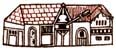
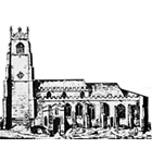
| R4 |
St. Peter
M in Speed's key. The church
stands on the north side of the bridge to the suburb of Stoke.
Mentioned in Domesday as being held by Ascar (or Asgar, Wisgar), and afterwards
by Richard Fitz-Gilbert, founder of the de Clare family, along with six carucates
of land and 13 burgesses. At that time
the river's edge was probably much closer to the church than today.
The Augustinian priory of St. Peter and St. Paul was established nearby
around the close of the reign of Henry II; the founder is unknown,
although the king was claiming its patronage by the time of Henry III.
The priory was fairly wealthy by the end of the 13th century, holding
the appropriation of the churches of St. Peter, St. Nicholas, and St.
Clement. Royal licences to acquire property in mortmain allowed for a
period of expansion into adjacent properties in the early 14th century.
The Priory was dissolved in 1526 (by which time it was also holding
the church of St. Mary Quay) in order to allow for Cardinal Wolsey to
construct his short-lived college on the site.
(image of St. Peter's)
|
| R5 |
St. Mary Quay
N in Speed's key. Believed to be in existence by the end of the 11th
century, but not necessarily one of the St. Mary's mentioned in Domesday.
It was clearly established to serving increased population around the
quayside. Yet, despite the importance of the quayside, the Poll Tax of
1381 indicates that this parish was not heavily populated. Much of the
fabric of
the church
now standing dates from the mid-15th century.
|
| R6 |
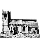
St. Mary Elms
F in Speed's key. If the two St. Mary's mentioned in Domesday are, as
seems likely, St. Mary Tower and St. Mary Stoke, this suggests St. Mary
Elms may not have come into existence until the late 12th century.
(image of St. Mary Elms)
|
| R7 |
St. Mildred
Likely a pre-Conquest foundation, quite possibly dating as far back as
the 8th century. The church itself is rarely mentioned, particularly
after the early 14th century, although its cemetery is referred to in
1420 and the parish as late as 1465, along with the cemetery. References
to St. Mildred's are noticeably fewer than to other of the parishes within
the defensive perimeter. It may have been in gradual decline for some
time: perhaps part of the population originally served had been displaced
by the building of the castle (as at Norwich) and had moved east into
St. Mary Tower and St. Margaret parishes; events such as a fire in the
fleshmarket ca.1319 (the western part of which would likely have been
in St. Mildred's parish) may not have helped matters, and depopulation
resulting from the Plague and its recurrences would have reduced the base
of tithe-paying parishioners further, to the point where the church may
have had difficulty supporting itself. The parish may have been a small
one from its origin; a royal tallage of 1228 lumped it in with St. Mary
Tower for purposes of listing taxpayers, while in 1309, when men were
chosen from each parish to elect a town council, with different numbers
of electors according to the size of the parish population, St. Mildred's
was not listed at all. The church building was subsequently absorbed
into the moothall property; it survived into the 19th century, when
pulled down to be replaced by a new
town hall.
Judging from parish boundaries, it looks as though St. Mary Tower parish
was extended to absorb the part of St. Mildred's east and south of Cornhill,
while the western portion was added to St. Matthew's.
|
| R8 |
St. Nicholas
L in Speed's key. Not mentioned in Domesday, it likely came into being in
the following century, to serve residents spreading along the road
connecting the town centre with Stoke. However, there may have been an
earlier church with a different dedication on the site. The parish contained the timber
market (perhaps located south of the Franciscan friary?).
|
| R9 |
St. Edmund's chapel
A chapel dedicated to St. Edmund de Pounteney (Pontigny) was located
between Lower Brook Street and Foundation Street (an earlier name for
which was St. Edmund Pounteney Lane), with its rectory on the corner of
Rosemary Lane. This was an unusual dedication, referring to an Archbishop
of Canterbury canonized in 1248. It is first mentioned in Ipswich
records in the last decade of that century, when a member of one of
Ipswich's most prominent families was its chaplain; burial privileges
were evidently associated, since its cemetery is mentioned in 1338.
Originally belonging to St. Peter's Priory, in the 15th century it was
consolidated with St. Helen's.
|
| S1 |
St. Mary Stoke
P in Speed's key. It was probably one of the St. Mary's mentioned (without
any distinguisher) in Domesday, whose entry for Ipswich clearly includes
Stoke. Elements of the medieval church survive within a
later rebuild.
|
| S2 |
St. Augustine
Mentioned in Domesday as being held by Lestan the priest, it was probably built,
or rebuilt, by the eleventh century, to service a small suburban community that
had developed, in a marshy area, during the Middle Saxon period; barrow burials
at one end of the area indicate it was in use by at least the tenth century.
It and its church were located at the southern end of Stoke, but were not part of
the Ely liberty in Stoke; the parochial community was not a prosperous one,
judging from the lack of grave goods and the inclusion of lepers among
those buried, while a few skeletons evidencing syphilis and the repurposing of
boat timbers for burials seem reflective of a quayside area frequented
by a transient population of mariners. The church decayed and disappeared –
or perhaps was used by a leper hospital dedicated to St. Leonard (a poor foundation,
likely reliant on alms and bequests) established in the adjacent parish of
St. Mary in 1474 by burgess
Richard Felawe – during
the Middle Ages (though still in existence tempore Edward II), and its
precise location was forgotten, which is why it is not acknowledged on Speed's map.
The foundations were discovered when its neighbourhood and cemetery were
excavated by archaeologists in 2012.
|
| S3 |
St. Margaret
C in Speed's key. Probably built in the 12th century, when the church of
Holy Trinity was turned into a priory (there would otherwise be no sense
to have two parish churches immediately adjacent). The most populous
parish judging from the Poll Tax of 1381, containing 19% of those taxed;
this was partly because it was a large parish, incorporating Carr Street
and its surrounds within the defensive perimeter as well as a suburban
area. Again, in a parliamentary aid of 1463, St. Margaret's had the
highest assessment of any parish (just edging out St. Mary Tower) and
had 3 assessors, compared to 2 for each other parish.
The church
survives as a fifteenth century rebuild.
|
| S4 |
St. Clement
K in Speed's key. The suburb just outside the defensive boundary was
established in the late 12th century, probably as a result of growing
settlement in the vicinity of the quay. It was one of the more populous
parishes in 1381.
|
| S5 |
St. Helen
I in Speed's key. A suburban church in the hamlet of Caldwell, it is
believed to have been in existence by the end of the 11th century. It
seems to have been annexed to the combined hospitals of St. Mary
Magdalene and St. James (see entry under Hospital of St. James).
|
| S6 |
St. Matthew
D in Speed's key. Believed to be in existence by the end of the
11th century. The parish included a chapel dedicated to All Saints
and St. John's Hospital.
|
| S7 |
St. George's chapel
B in Speed's key. Mentioned in Domesday, not as part of the Ipswich
entry proper but in the same half-hundred, as part of the hamlet of
Baylham – where several burgesses were already established. This suburb
never developed much and remained one of the borough's smallest parishes
in 1381. In 1451 a St. George's fair is heard of, although whether
connected with the chapel, I cannot say.
|
| T1 |
Holy Trinity Priory
A in Speed's key. A church with this dedication is identified in Domesday,
as being held by Alnulf the priest. It may have been the precursor of
the building that later served as the Augustinian Priory of the Holy
Trinity, established tempore Henry II. It was, at the time of
Domesday, presumably a parish church, but must have been a priory when
St. Margaret's (its replacement) was built on adjacent land. The first
priory building was constructed in 1177. At the beginning of the 13th
century it held the borough churches of Holy Trinity, St. Lawrence, St.
Mary Tower, and St. Mary Elms, along with other churches and lands in
the vicinity; by the end of the century, it also held St. Margaret.
The Priory was sometimes known, as early as tempore Richard II,
as Christ Church. Taken over by the Crown in 1536 and acquired by a
London merchant a few years later, the priory ruins were rebuilt into
a manor house now called
Christchurch
Mansion.
|
| T2 |
Franciscan friary
T in Speed's key. The Greyfriars, or Friars Minor, were established in
Ipswich early in the reign of Edward I; in 1284 townsman Robert de Orford
bequeathed them a small sum of money. The founder was Sir Robert Tiptot
(died 1298) of Nettlestead and wife. Not much is known of the friary,
although it covered a fairly large tract of land in what was otherwise
a relatively uninhabited section of the town (on land once marshy), and
left a memory in several topographic features in the post-medieval
period; for example, the street leading along the edge of the precinct
became known as Grey Friars Road, an easterly approach to the site is
still (at least the surviving part) known as Friars Street, while the
bridge leading across to the common marsh was known as Friars Bridge
(by at least 1419). The friary was suppressed in 1538.
|
| T3 |
Carmelite friary
V in Speed's key, but he misidentifies the convent as the Blackfriars.
The Whitefriars probably established themselves in
Ipswich around 1278; townsman Robert de Orford bequeathed them a small
sum of money in 1284. Settlement of Carmelites here was perhaps the
result of a decision of the provincial chapter held at Norwich in 1278,
and the new community could have drawn its initial members from the
Norwich Carmelite house. The friary absorbed a large area of the town
just south of the town centre, bordered by Queen Street on the west and
St. Stephen's Lane (on the west side of St. Stephen's church) on the
east. The fact that provincial chapters were often held at Ipswich in
the 14th century indicates the friary must have had the capacity to
accommodate a large number of guests and, indeed, the central structure
shown on Ogilby's map (1674) confirms this, although the church was
rebuilt in the third quarter of the 15th century. It was suppressed in
1538.
|
| T4 |
Dominican friary
W in Speed's key. A Dominican friary, dedicated to St. Mary, was
established at Ipswich by Henry III, who in 1263 purchased a property
there for the initial buildings. During the 13th century, there were
perhaps over fifty friars in the community. John Ogilby's map of
Ipswich in 1674 (the first large, detailed, to-scale plan of the town)
shows a "Friery Garden" to the south of an unidentified building, which is
called Christ Hospital – apparently some kind of almshouse – on Speed's
map (and again so identified on Pennington's map of 1778). This was a
surviving reflection of a large precinct built up by the Blackfriars
over the course of the Late Middle Ages, stretching from the church of
St. Mary Quay to the south, what was later called Foundation Street on
the west, the town defensive line on the east and an uncertain distance
north – perhaps as far as the north-eastern corner of the defensive
line. King and borough permitted considerable expansion of the friary
property on condition that the burgesses had access to the adjacent
town ditch (and later the walls) for purposes of repair, and the friars'
promise to assist with maintenance of the wall and two gates on the north
and south sides of their property, through which public access was to be
allowed. The line of houses shown by Speed on the east side of this
precinct, where once a town wall would have stood, presumably did not
come into existence until after the suppression of the friary in 1538.
There is a reference in 1462 to a road running between Blackfriars
Bridge and the quay; it is not clear where this bridge may have been
located, unless it led out of one of the eastern gates, across the
town ditch.
|
| T5 |
Hospital of St. James
Little is known of this except from incidental references. It lay in
the suburban part of St. Margaret's parish, probably on the border of
St. Helen's parish, and near a lane (itself perceived as running roughly
north-south) leading to St. Helen's. Based on this I have hypothesised
that Speed may have represented the hospital (without identification)
as a building shown set back a little from the road, separate from the
main line of residences; these buildings were just barely within the
boundaries of St. Margaret's parish and were backed by an area of
unoccupied land not clearly associated with any parochial jurisdiction.
The hospital housed both men and women and was intended for lepers.
Besides St. Leonard's (see entry under St. Augustine), there were two
other leper hospitals in Ipswich, dedicated to St. Mary Magdalene (in
the vicinity of St. Helen's church) and St. James; that of St. Mary
Magdalene was first mentioned in 1199, when the king granted it a fair
to be held on the day of St. James Apostle, on its own land. In the
14th century the hospital of St. James was united with it, to be
administered by a single master. In addition we hear of a hospital
which sheltered the poor (1339) in the suburban part of St. Matthew's
parish, and a Hospital of St. John of Jerusalem (1414) in St. Margaret's
parish.
|
| |
WARD BOUNDARIES
The following are the extents of the leets, as of the early fourteenth
century, given in the Black Domesday (Suffolk Record Office, C4/1/1 f.70).
I have added some notes in parentheses.
|
| |
Eastgateleet
Extends from Northgate, from the east side of that street [that is, Brook Street],
to the stone cross called Lewys' Cross in Brook Street, and thence to the
left as far as the town ditch near the Friars' Preacher, incorporating Cary Street,
Thingstead, and Caldwell Street.
|
| |
Westgateleet
Extends from Northgate from one side of the street in front of the gateway
of the archdeacon of Suffolk [a location on the right-hand side of the north end
of the street, today known as Pykenham's Gateway, after the late fifteenth century
archdeacon who rebuilt it] as far as the course of the street which leads from
Brook Street to the fish-market, and thence through that market, on the right-hand side,
to the corner of the Water Cobbe, continuing along through the corn-market,
then along one side of the High Street as far as Westgate, and including the suburb
outside that gate. [These boundaries seem to skirt the posited site of the castle bailey,
as do those of the Southgate Ward, providing further support for the existence of
such a precinct, which would have been administered separately from the borough proper.]
|
| |
Southgateleet
Extends from Westgate, along one side of the High Street towards the south
as far as the east end of St. Mildred's church, and thence [southwards]
along the right-hand side of the street as far as Woulfounes Lane in
St. Peter's parish.
|
| |
Northgateleet
Extends over the remainder of the town, including the bridge, the suburb beyond
the Quay, and Clement Street.
|
 History of
medieval Ipswich
History of
medieval Ipswich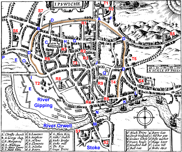