The medieval defences of towns elsewhere in Europe can provide contrasts and comparisons with those of England. Not surprisingly, many of the same themes are encountered.
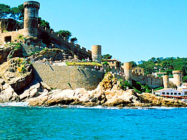
Although Catalonia boasts several fortified villages in its interior, Tossa de Mar is its only coastal community where the early settlement (known as the Old Town) is still surrounded by medieval walls. That settlement grew up on the slope of a cape, known as Mont Guardi, at whose peak the feudal lord, had erected a small castle. It is believed that, much earlier, an Iron Age stronghold may have topped the promontory; the name Turissa, given by the Romans to the settlement they established on a site next to that of the later medieval village, has given rise to speculation about the presence of a watch-tower. In both Roman and medieval periods, agriculture, rather than fishing, was the mainstay of the local economy. The Roman settlement was destroyed by fire in the eighth century, perhaps the result of an assault.
The establishment of a seigneurial fortress must have stimulated revival of the village. In 966 the lord of the castle gave the Castrum de Tursia to the abbey of Ripoll, which was later able to argue successfully that not only the village but also the castle was part of the donation. The abbot endowed the settlers with a charter of urban liberties in 1187; at about that time, or a little later, he built a parish church on the slope between settlement and castle.
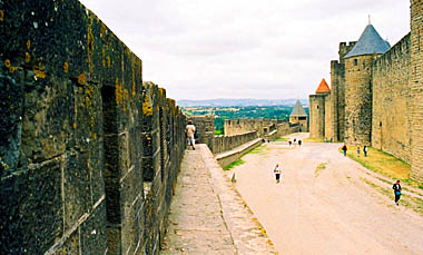
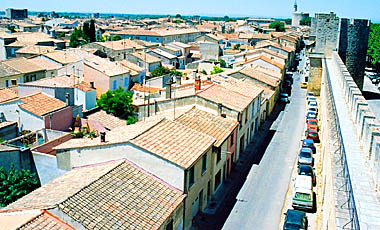
(above) The stretch of wall along one side of
the cape on which Tossa sat. The wall circled around to protect the
few hundred inhabitants.
Photo © S. Alsford
The town of Tossa was surrounded with a wall probably in the early thirteenth century, although much of the surviving fabric represents major refurbishment in 1387. The circuit protected the church and around eighty houses. It reflects the enhanced status of Tossa and indicates the growing need to deal with piratatic raiders, to whom Tossa's growing prosperity must have made it an attractive target. The wall augmented the natural obstacle of the steep rocky slopes of the cape. Visible from far out at sea, it may have been intended as a psychological deterrent as much as a real barrier.
Tossa's walled circuit incorporated four main and five intermediate towers. Of the former, one tower (now demolished) was successor to the castle, a second kept guard over the cove that served as the town's harbour, a third stood on the other side of the cape facing out towards the southerly sea and coastline and was the base for the night-watch, while the fourth stood beside the sole gateway through the walls, leading into the Plaza de las armas, from which there were two minor gateways into the town's interior; in the fifteenth century the town's first clock was installed in this tower. The gateway was protected by a gate on either side; in the event of raiders being spotted approaching by sea, the space between the gates was filled with sacks of sand, to obstruct a breach at this point. Not until the threat from pirates diminished in the sixteenth century did the townspeople feel secure enough to expand settlement beyond their walls.
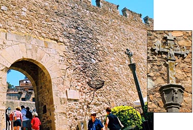
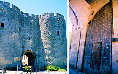
Just inside the town wall, and beside
the sole gateway through it, stands one of the boundary markers
for the town (the inset shows in more detail the
carving atop the column).
Photos © S. Alsford
Vence, in the southeastern corner of France, could, like Tossa, be considered a frontier town. The site of an Iron Age fortified settlement and later a Roman town (possibly with augmented defences), situated on a route from the coast into the interior, its region was subjected throughout the Middle Ages to invasions by various peoples or forces, although the only siege that Vence is known to have undergone took place in 1592. A stone wall was built around the town during the thirteenth and fourteenth centuries, in phases that involved successive strengthening, heightening, and crenellating; it enclosed an oval roughly 200 metres long by 150 wide, within which modest space population may have risen to a peak of around a thousand, before plague struck. Vence was by 439 an episcopal seat, the bishop later being one of the lords of the town (the other being the count of Provence).
The walls were built just inside a ditch (perhaps water-filled), which served as an earlier defence around at least part of the site. Until 1441, the circle of walls was pierced by only two gates, tower-topped and probably of the thirteenth-century, situated at either end of a diagonal crossing the oval. One was the Portail Lévis, named for the drawbridge outside it, crossing the ditch, and also known as the North Gate. the other, the Porte du Signadour, its name not derived from a conjectured signals-man (or watchman), although its function as a watch-tower across the valley is likely, but rather from a provençal term for chapel, which stood close by. This second was also served by a drawbridge and possibly a barbican as well as a wooden bretask atop the tower.
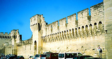
Remnants of Vence defences.
(above) What is visible here, behind the water fountain in
the Place Antony Mars (itself a replacement for a fountain
installed 1439) is a stretch of the town wall, incorporating
the Tour du Signadour. We can see how the wall has become
incorporated more closely into the urban fabric, pierced by
doors and windows of the houses built onto it.
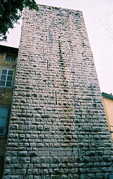
(below) The Tour de Peyra (Stone Tower) is not associated
with a medieval gateway and, although its date of construction
is unknown, may have been a stand-alone fortification prior to
the erection of the walled circuit. Slits for crossbowmen to
fire through can be seen. It would probably have been topped
by a wooden platform, from which defenders could drop missiles
onto assailants. In the fifteenth century the tower was made
part of the count's residence in the town.
Photos © S. Alsford
During the fifteenth century, a period of relative peace in the region, houses were being built against Vence's wall, to its full height, so that the tiled roofs could overhang; crenellations were blocked up or infilled with windows. later, other windows and doorways were cut through the walls from these residences. It was precisely this absorption of the wall into the residential fabric that has led to much of it being preserved. The ditch was being filled in during the fifteenth century, a process begun before 1431, when a public plaza was laid out along the portion of it outside the Porte Signadour. the route of the ditch is now a ring road. Additional gateways were subsequently inserted to give better public access between the intra-mural facilities and spaces outside the enclosure, including the faubourg (suburb) that developed to the south.
On the opposite side of southern France, in Languedoc, Carcassonne is probably the most famous of Europe's medieval walled towns, thanks to the ambitious effort in the nineteenth century to restore its dilapidated fortifications to their late medieval condition, and the subsequent reconstruction of a ruinous and largely deserted urban fabric into an infrastructure that now supports massive tourism.
Although the Celts had established a defended settlement nearby, the elevated site that developed into the medieval town had its beginnings with colonization by Roman veterans. Some of the remaining fortifications are Roman in origin. Carcassonne's position put it in the path of invading peoples from both north ad south; in the Early Middle Ages it came under the control, successively, of Visigoths, Saracens, and Franks, and was clearly in need of sturdy defences. After the dsintegration of the Carolingian empire, the region's counts became independent rulers; They augmented the existing fortifications around the town and, in the late eleventh century, initiated the construction of a cathedral there and, in the early twelfth century, of a castle that incorporated a stretch of the western wall.
In 1209 the city was besieged by forces of the Albigensian Crusade, led by Simon IV de Montfort its encircling walls were already strong and the siege is said to have succeeded, after two weeks, only due to lack of water and treachery. Another siege took place in 1140, when the disinherited son of the count tried unsuccessfully to recapture Carcassonne. King Louis IX, now in control of the city and conscious of its potential as a stronghold near France's frontier with Spain – the king of Aragon at that time pursuing expansionist ambitions in western Languedoc – initiated a programme to strengthen the city defences, continued by his son in the late thirteenth century. The castle was enlarged and refortified, and a larger garrison stationed there. A second set of ramparts was built around the first and the inner ramparts were repaired, heightened, crenellated, a nd made more defensible. New towers were added, or rebuilt on foundations of towers that had stood at an earlier time.
Stretches of the double ring of walls, on the southern side
of the Citadel, can be seen (the outer ring is on the left), separated
by a wide open space known as the Lists, which served for staging, storage,
and training, among other uses. The inner ring is 1100 metres in
circumference, the outer ring 1500 metres. The proportion of defenders
per length of wall was about the same as for the English burhs.
48 towers and 4 barbicans were part of the defences; it has been estimated
that over 1,300 soldiers would have been needed to man the defences properly.
Photo © S. Alsford
The seeds of decline the Carcassonne citadel had, however, been sown with the relocation of many inhabitants from the badly damaged town to a new urban foundation, laid out on a rectilinear grid on the far bank of the River Aude. The Citadel's now formidable double ring of fortifications, benefiting from the latest advances in military engineering, saved it in 1355, When the Black Prince arrived on campaign. He left the Citadel alone but the Lower Town, protected by a more modest wall, was sacked. It was quickly rebuilt and came to eclipse the old Citadel in terms of trade, prosperity, and population.
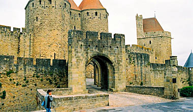
(above) The Narbonne Gate was and is the main entrance into the citadel.
Here we see, in the front of the picture, one end of what would once have
been a drawbridge over the outer ditch, leading into the barbican which
gave access the the Lists, and beyond it the Narbonne Gate itself, topped
by a tower and flanked by two larger, tapering towers (built about 1280)
about 25 metres high. To the right of the photo is seen the Treasure Tower,
built about the same time, to help protect the gate.
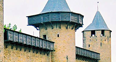
(below) The upper part of each of the Narbonne Towers would have been
fitted out with a wooden gallery from which defenders could attack
those assaulting the base of the gateway. A reconstruction of such
galleries, known as 'hoardings' supported on timbers projecting from
holes in the walls, has been installed for one of the castle towers
and its adjacent walls (east side). Sentries would also have used
these galleries.
Photos © S. Alsford
Louis IX was also instrumental in the construction of another fortified town that has come down to us in an excellent state of preservation: Aigues-Mortes. Its foundation as a port on the Mediterranean coast of Languedoc was part of the larger plan of the monarchy to reassert its authority across France (as had been the Albigensian Crusade) and to capture a share of the growing Mediterranean trade involving Spain, Italy, North Africa, and the Levant, following the decline of Muslim influence there. Since at least 1226, and perhaps long before that, merchants had been using this marshy stretch of coast, a delta of the Rhone and Durance rivers, characterized by sheltered but stagnant lagoons bordered by banks of sand and silt, as a harbour. Louis was also interested in establishing a Mediterranean base from which he could launch a crusade to retake Jerusalem from the Saracens (something he had, in 1224, taken oath to do).
In 1241 King Louis, having undertaken a forced resettlements of masons from a neighbouring town, had work begun at Aigues-Mortes; one of the first construction projects was the Constance Tower – perhaps originally envisaged as the sole defence of the town, it would become the anchor for the fortified circuit at its northwest corner – and he then expanded it into a castle, completed in 1254. At the same time he was finalizing negotiations to acquire the site from the abbey that owned it, so that he could put up an entire town; in 1246 he granted the existing residents a charter of very advantageous liberties and incentives (such as tax exemptions), to attract more settlers. He improved access by road to the site and had two canals dug to connect the new town with Montpellier and Arles and tie Aigues-Mortes into the trade route between the fairs of Champagne and the Mediterranean. These canals were used to bring in much of the stone for building the urban fortifications. Meanwhile, with construction on the town underway, Louis used the port as the base for stockpiling supplies and assenbling and launching expeditions to the Holy Land (1248 and 1270).
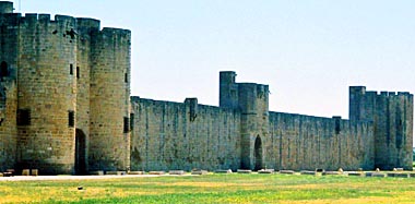
A stretch of the southern side of the
Aigues-Mortes walls; seen here, left to right, are the
Marine Gate, the Arsenal Gate, and the Powder Tower
(all post-medieval names).
Photo © S. Alsford
Louis' successors continued this work. The town walls were built during the last quarter of the thirteenth century, spurred on by a Spanish naval attack in 1286. In 1278 work began on new port facilities that would enable flat-bottomed vessels (e.g. galleys) to sail right up to the city walls. The territorial endowment of the town was also increased. Aigues-Mortes found itself a focus for maritime commerce and its population grew to several thousand inhabitants.
However, silting of the harbour and competition from Marseille (acquired by France in 1481), as well as the unhealthy clime of the marshes and lack of agricultural land, put paid to Aigues-Mortes' commercial dominance by the late fifteenth century. It continued to serve as a stronghold in the Wars of Religion but its economic decline and its isolated geographical location helped it avoid forces of change that might have lost for us some or all of its medieval fortifications. These have survived with relatively few adaptations to artillery warfare or modern reconstruction.
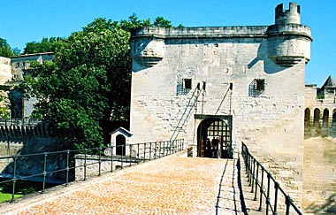
The main entrance into the town is the Gardette (guard-post) Gate,
seen here (at left) with its two flanking towers from the exterior.
One of its pair of reinforced gates is shown at right, incorporating
a smaller doorway for pedestrian access when the main gate was locked;
note also the slot for one of the pair of portcullises.
Photos © S. Alsford
The walled circuit at Aigues-Mortes is roughly rectangular and about 1640 metres in length, the walls being 11 metres high. Its outworks comprise 5 large gateways, 5 smaller ones, 2 flanking towers, 3 corner towers, and the Constance Tower. Because of the short time-frame in which the defences were built, building style and materials are fairly uniform, although some variation points to successive stages of construction. The flanking and corner towers, and perhaps parts of the walls themselves, were once furnished with hoardings, to serve archers, as at Carcassonne.
In contrast to Vence, at Aigues-Mortes the separation of defensive walls
and residences by an open space around most of its interior circuit
still exists, as this photo from the north-side parapet walkway shows.
At perhaps no other medieval walled town is the relationship between
military and civilian fabric so well preserved. On the right-hand
side the Gardette Gate can be seen with the Constance Tower beyond it.
At upper left, across the urban rooftops, can be made out south-side
towers: the Mill Gate and the Des Bourguignons Tower (north-west corner
of the circuit)
Photo © S. Alsford
Avignon's story shares some similarities with those of the other French towns looked at above. Its site, within a bend in the Rhone river, was inhabited and possibly fortified from prehistoric times, and was a moderately important Roman city, again (conjecturally) walled. Being in the contested region of Languedoc, it fell under the control of various authorities at different times during the Middle Ages, and was in Saracen hands when, in 737, besieged and sacked by the Franks. In the eleventh century it was under the lordship of the count of Provence and a bishop, but in 1129 a dying count transferred authority to to the bishop and city leaders and the community took on the status of a largely self-governing commune, with the bishop as titular head.
At this period the city was prospering from the growth of trade across Europe. Between 1177 and 1185 was undertaken the construction, across the turbulent waters of the Rhone, the of famous bridge of Avignon, named after (Saint) Bénezet, who raised the alms for the initial phase of the project; it was intended to serve merchants and pilgrims travelling between France and Italy, to attract commercial traffic away from other crossing points, and to connect the city with its main harbour facilities on the opposite riverbank. 920 metres long, it probably extended as far as the walled circuit around the city.
That circuit had been erected (likely on the line of Roman ramparts) in the eleventh century and augmented in the early thirteenth by a second ring of walls, with a water-filled ditch between it and the older ring. However, like Carcassonne, Avignon was caught up in the Albigensian Crusade; in 1226 it closed its gates to Louis VIII's army and underwent another siege. After three months the starving citizens surrendered. Thereafter some of the walls and the greater part of the bridge were demolished, and the moat filled in; Louis forbade any rebuilding of the defences for five years. The city once more became subject to the overlordship of a count, its commune disempowered.
Avignon had recovered sufficiently from the setback to begin, in 1234, building new walls, on a different line from the old circuit; the project continued into the 1240s, but again the defences were partially dismantled in the 1250s. A significant boost to the city was given in 1309 when Pope Clement V set up residence in AVignon; the papal seat was later formally transferred there and remained so until 1377, and then as one of the papal bases during the Great Schism, until 1409. Consequently more new wealth, new business, and new settlers were attracted to the city, whose residential area expanded well beyond the thirteenth century enclosure, to accommodate up to an estimated 30-40,000 inhabitants. In 1348 Clement VI purchased the city from the countess of Provence.
A small stretch of the walls surrounding Avignon
gives a fair sense of the circuit as a whole, since the overall style is
much the same throughout. The walls have been restored in the modern period,
not always sympathetically.
Photo © S. Alsford
In 1355 Benedict XII had a new wall begun to incorporate the expanded area of settlement, a project not completed until the next century. This is the line of defences which still stands today; although the older line was needed as backup – when, during the 1350s and '60s, the city was threatened by mercenary forces at loose ends during lulls in the Hundred Years War and finding wealthy Avignon an appealing target – little of it has survived.
The new circuit was some 4,330 metres in length, and incorporated seven gates with drawbridges across the surrounding moat, 35 large towers, and 50 smaller towers. Its length would have made it challenging to defend, but strength and defensibility seem not to have been a primary consideration; the walls are only 8 metres high. The Popes appear to have relied for protection more on their strongly-built palace within Avignon (incorporated into the line of the eleventh century city wall), as well as on the wealth of the Church to buy off the freebooting mercenary companies.
Repairs to the Saint Bénezet bridge were underway by 1237 and continued throughout that century; further work was supported in the fourteenth century by the papacy. The bridge was protected, and access controlled, at the point of the city wall by a châtelet ("small castle") that, spanning the bridge, served as an entrance gateway. At the far end of the bridge. where King Philip the Fair converted a village into the town of Villeneuve (1292), he built a fortress (to the annoyance of the citizens of Avignon, who felt they had jurisdiction over that bank of the Rhone; only its tower still stands. Defended bridges are known from medieval England (e.g. London Bridge and, at Norwich, Bishop's Bridge), although the only surviving bridge gatehouses are at Monmouth and Warwkworth.
Avignon bridge châtelet. The original, built
in the mid-fourteenth century, was replaced by a larger one between 1375 and
1382 and rebuilt in the early fifteenth century. The rectangular gateway,
equipped with a portcullis on one side and decorated with coats of arms,
comprises two storeys atop a cellar. The second storey was added in 1489-90,
along with the small turrets (for watchmen) at each corner.
Photo © S. Alsford