|
NOTES:
|
| |
This is in fact part of a larger plan showing Yarmouth and its surrounds
in the time of Queen Elizabeth I. In most of its details it
well reflects how Yarmouth must have looked at the close of the fifteenth
century, although there are of course post-medieval features. This plan
is presented to give a general sense of the appearance of the town, but
should not be trusted for accuracy.
|
| |
THE WALLS
Construction began in the 1280s but the bulk of the work seems
to have been carried out over the course of the 14th century,
particularly its central decades.
Yarmouth's early historians thought that work began on the north-east
portion (adjacent to St. Nicholas') and proceeded southwards, and that
the northern stretch was perhaps the last part to be undertaken. However,
it now appears that construction may have been underway at different
locations at the same time. The sequence of the entire work remains
uncertain, but in the late 1330s and early 1340s work was taking place
in the vicinity of the Dominican friary, including on the South Gate,
and by 1344 there was activity on the northern stretch.
The completed circuit incorporated 10 gates and 13 towers. The style
of what survives is sufficiently similar to suggest the original circuit
was all part of an overall plan. However, not all sections were initially
built to the same height. Heightening of shorter sections occurred
spasmodically, along with repair work, for the rest of the medieval period.
|
| 1 |
South Gate
Probably erected in the mid-14th century. The North and South Gates were
the two main gates of the town; each was flanked by two towers.
|
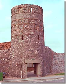
| 2 |
Blackfriars Tower
The tower stands some 30 feet high, with the adjacent wall
about half that height. The arrow-slits were for defenders
inside the lower chamber of the tower. The passageway
beneath the tower is post-medieval.
|
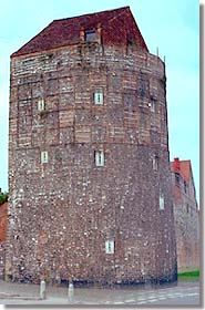
| 3 |
South-east Tower
Also about 30 feet in height. The arrow-slits are made from
blocks of Caen stone. The superstructure is post-medieval.
|
| 4 |
This appears to represent a fortification added in the post-medieval
period, in response to the threat from Spain; if so, the artist has
greatly truncated the stretch of wall between it and the South-east
Tower.
|
| 5 |
Market Gate
|
| 6 |
Pudding Gate
|
| 7 |
King Henry's Tower
Thought to have been named after Henry III who first licenced the borough
to construct walls. Whereas other towers are D-shaped,this one has an
octagonal plan. |
| 8 |
North Gate
Local legend had it that this gate was built with grateful donations
from those who survived the Black Death. Whether true or not,
the style of the gate would be appropriate to that period.
Two leper-houses stood a short distance north of the gate.
|
| 9 |
North-west Tower
|
| |
THE DENES
The Denes were an extensive beachy area on the east side of the walled
town. As can be seen from the depiction, townsmen let their animals roam
here. Also visible in the complete depiction (but not in this cropped
version) are the windmills that had been built on the Denes since the
time of Edward I, and were a source of complaint by the Cinque Ports men,
who charged that they interfered with the drying of fishing-nets (of which
an example is also shown in the complete depiction); in 1277 Edward ordered
a limitation on the number of windmills there. This right to dry
their nets there was part of the rights of "den and strond" granted the
Cinque Ports men by Henry II; the nets were hung from ships' masts. The
beach was also used as an area for building ships, while old, derelict
ships abandoned there was another source of annoyance to the Portsmen.
|
| |
WITHIN THE WALLS
|
| A |
Dominican friary
The Black Friars were said to have arrived in Yarmouth in 1267. They
obtained licence from the king in 1271 to acquire a plot of land
(referred to as being part of "La Straunde", i.e. the beach) 500' x 500'
to expand a narrow strip of property already possessed at the
south end of the town; on this land they had built a convent by 1273, lying on
the south side of the marketplace. This was subsequently extended,
thanks to burgess benefactors, into a large precinct.
|
| B |
Dene side |
| C |
St. Mary's Hospital
Founded ca. 1278.
|
| D |
Marketplace
The two features on either side of the "D" appear to represent the market
cross (left), which sat atop an open-sided roofed building, and the
pillory (right) that were set up there in 1395, when the market was also
partially paved, as a result of a pavage licence obtained from the king.
|
| E |
Community wells |
| F |
St. Nicholas' Church
Antiquarians are divided on whether this was founded on the site of
the St. Benedict's mentioned in Domesday, or superseded a chapel built
two decades before the church; it became a source of dispute between the Bishop
of Norwich and the Cinque Ports fishermen as to who would appoint the
priest. It has been suggested that the Bishop of Norwich built the church
with some of the Caen stone he was importing for the construction of
Norwich cathedral. It was enlarged in the mid-13th century and again
in the 1330s.
|
| G |
Charnel house
The "Carnary" was built in the churchyard ca. 1308 through the benefaction
of Sybil, widow of William Flathe. This was no easy task, since it required
permission from the Bishop of Norwich, the King, and the Pope. Its purpose
was to house the bones of those whose graves were dug up to make room for
new inhabitants. Sybil endowed this chapel with various rents (for whose
collection and application the borough government was made responsible) in
order to support two priests to perform divine services for the dead. She
herself died in 1311. The charnel was pulled down after the Reformation.
|
| H |
Benedictine Priory
Situated on the north side of the marketplace, this was founded by
the Bishop of Norwich in 1101, as a cell of Norwich Priory, and when the bishop
subsequently had St. Nicholas' built it did doublte duty as parish and priory church.
|
| I |
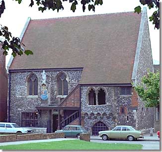
Tolhouse
Located in the earliest settled part of town, it is suspected
that its core was built ca. 1150 (an archway of that period, now blocked,
is still incorporated), but with the forebuilding added ca.1250. Originally a
residence with a hall on the first floor. The choice of materials -- flint and rubble
(with stone dressings) -- and the height of the building have given rise to
the suggestion that it may have been a fortified house, and it is later known to
have been acquired by a prominent townsman whose family was involved in a deadly feud
with other leading families. It subsequently became the seat of civic administration.
|
| J |
Great Middlegate (street)
The southerly portion was sometimes known as South Middlegate or
even Southgate
|
| K |
Little Middlegate (street)
Known from the 1330s as Blind Middlegate
|
| L |
Northgate (street)
|
| M |
Franciscan friary
Established at some time in the 13th century, perhaps as early as 1226,
although the Gerberge family was said
to have been the Grey Friars' patron and one member of it the friary's
founder in 1271. It may have been begun close to the river's edge and
extended northwards as land was reclaimed from the river. There are some
minor
remains of what is believed to have been this friary.
|
| N |
Carmelite friary
Also located close to the river (again, conceivably on reclaimed land)
the White Friars convent was said to have been founded ca. 1278. The various
orders consumed so much of the limited space in the town that when the
Augustians arrived, latecomers, they established themselves in Little
Yarmouth instead and had to be satisfied with a cell in Great Yarmouth.
|
| O |
Bridge to West Yarmouth
The king gave the town permission in 1417 to built a bridge to replace a
ferry service; it is not clear whether this was accomplished immediately
or until a few years later.
|
| P |
Probably represents a mechanism for weighing merchandize (trone),
given its central location on the quayside and near the bridge into
town.
|
| Q |
Quayside
Since it stretched along the length of the Yare bank, sections of the
quayside were distinguished from each other by their own names.
- The Lord's (i.e. king's) Quay, probably the earliest port area.
- As its name indicates the Crane Key was where the borough crane was
located; the borough had the right (although this was challenged by
Norwich) to charge a fee for use of the crane for
loading and unloading of cargos.
- As the port silted up, harbour facilities had to be moved further
south along the east bank of the Yare, and population followed it.
Consequently, in the 15th century the South Quay was an area in which
many of the town's wealthier merchants lived, and one house there
was being used in 1317 for wool staple administration.
|
| R |
The Conge
This was an area of the Lord's Quay. The name is possibly associated
with a French term used in relation to the clearances to depart that
ships' masters had to obtain from the authorities. It was perhaps here
that there was a house for collection of
customs (unless the Tolhouse served that function) – without
payment of which, ships would not be allowed to depart.
|
| S |
The Foreland
An open plain for much of the Middle Ages, residences were built upon
part of it during the 15th century.
|
| T |
Possibly represents a building called (by the late fourteenth century)
the "Castle", and a nearby row was known as Castle Row.
A keep-like structure with corner turrets (judging from a post-medieval illustration),
its origins are unknown but it may have been the "Kingstonhus" heard of earlier, suggesting
an administrative function before the borough was chartered, and conceivably associated
with the Earl of East Anglia. During the Late Middle Ages it was in private hands; by
the time it came into the hands of the corporation, in 1550 (for use as a gaol), it was
in decay and was later pulled down. What may have been its foundations were uncovered
in 1965, and the depth of the foundations suggest a fortified building.
|
 History of
medieval Yarmouth
History of
medieval Yarmouth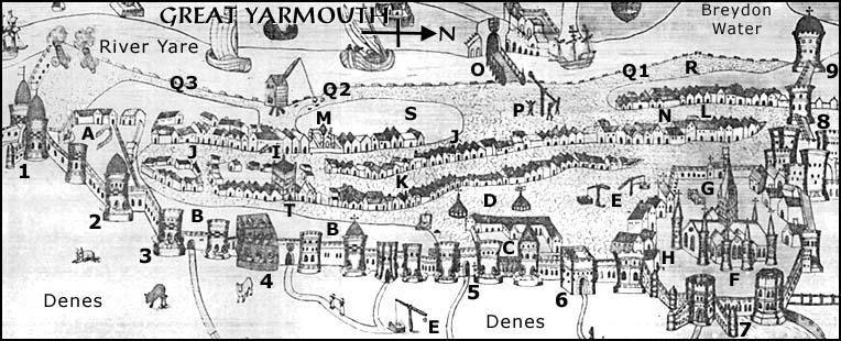