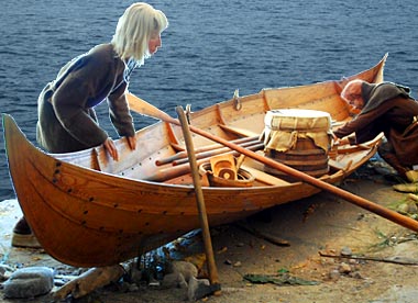
Goods being unloaded from a Viking faering.
Photo © S. Alsford
When Viking raiders and traders arrived at English coasts and estuaries, their longships were designed to be beached and did not require any docking facilities; the same was true of their lighter boats, called faerings, which were essentially rowboats (although they could use a small sail) suitable for river navigation. The Vikings also built sea-crossing cargo ships, or knarrs, that were rounder, deeper and shorter than the famed sleek longships; the merchantmen were powered primarily by sail and were not suited for beaching, but needed jetties or quays for loading and unloading. Residents of Anglo-Scandinavian England were certainly active in international trade, but we have comparatively few documentary references to it, although archaeology is beginning to flesh out the picture through excavations at coastal and riverside wiks as well as in key towns of the Danelaw, such as York.
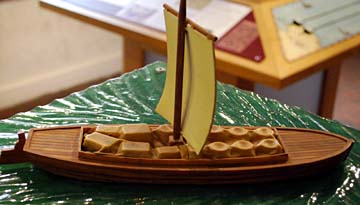
Model of a keel, carrying cargo, on display at Dragon Hall,
Norwich; this was the type of barge that Norwich merchants would have used to ship
their goods by river to Yarmouth for transfer to a sea-going vessel.
Photo © S. Alsford
In some ways a later medieval successor to the faering, though more the size of a longship, the keel was a shallow-draught clinker-built vessel used to transport goods along rivers that, at points, were no more than a few feet deep – such as that connecting inland Norwich with the sea-coast port of Yarmouth. In use by the thirteenth century, and probably earlier, they were necessarily quite narrow, compared to the fat sea-going merchant ships. As the model shows, they could be loaded with large cargoes. They were fairly manoeuvrable, and required only a very small crew, but their sail could not be adjusted to catch opposing winds, they had difficulty sailing against tides, and they required a dock. Norwich had a small community of keelmen living along part of Conesford Street, where there were many private and public wharves, and where Robert Toppes had his business establishment, now known as Dragon Hall.
An older site of the public quayside in Norwich than those established in the Late Middle Ages along the Conesford stretch of the river has regained some of that status in recent times. It was known as Fybrigge Staithe in the medieval period, and later as Fye Bridge Quay; today known as Norwich Quay, it serves rather as a fashionable residential area, pleasant riverside walk, and recreational boating spot than as a busy commercial dock.
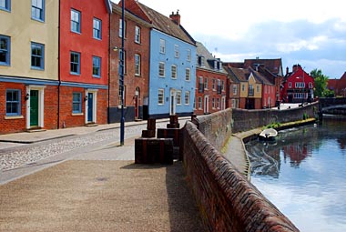
A stretch of the Wensum riverbank today known as Norwich Quay,
east of Fye Bridge (partly visible in the distance). The wooden blocks near the parapet
are some of a series placed along the quayside to symbolize bales of goods once unloaded
there from barges. The buildings lining the quayside are residential, yet recall
warehousing that is more commonly associated with ports.
Photo © S. Alsford
The Wensum played an influential role in Norwich's topographical development, economy, and history throughout the Middle Ages. In the Anglo-Saxon period goods brought by river, from the interior of the country, from along the English coast, and from as far afield as Scandinavia and Russia, were unloaded in the vicinity of St. Martin's church, only a short distance from the market of the Anglo-Saxon town. Along this part of the riverbank archaeologists have found evidence of efforts to consolidate the foreshore as well as buildings that might be interpreted as warehousing. Not only did this part of the riverside serve the import and export of goods, it also supported a number of fishermen who probably lived in the area known, by the thirteenth century (and probably earlier) as Fishergate; numbers of fishing-hooks and net-weights have been found there, mainly in eleventh-century contexts. More importantly, the river furnished resources for industries that produced some of the exported goods; for example, the clay that supplied potters, whose manufactures are the largest source of archaeological evidence for pre-Conquest industry in Norwich. Evidence of shoemaking has also been discovered near a possible ford (where Whitefriars Bridge was later built), and in the post-Conquest period, there are indications of tanners, skinners, dyers and fullers carrying out their work along both sides of the northern arm of the Wensum.
The focus for wharves – except for staiths serving the fishermen – shifted during the thirteenth century from the riverbank between St. Martin's and Fye Bridge to the southern stretch of the river, more easily accessible to cargo-bearing vessels (all the city bridges being further along). The move may have begun as the initiative of merchants preferring to live in that part of the city (Conesford) precisely because of the proximity to riverside docking; but before the end of the century a communal quayside had been established there, and in the later fourteenth century other public wharves were built there. Smaller boats able to navigate shallower waters and to pass under the bridges that had been built along the northern stretch of the river continued to make some use of the older quayside, which re-acquired some prominence after the Common Staithes had fallen out of use. The area has been rehabilitated in modern times.
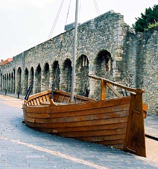
Modern replica of a fourteenth century vessel at Southampton.
Photo © S. Alsford
The replica of a small fourteenth century clinker-built cargo vessel represents a type that might have been used by Southampton merchants for short journeys shipping wool and wine the across the Channel; as a second replica next to it (not visible in the above photo) shows, such ships were constructed beginning with the keel, stern, and planking at the bottom of the hull. It is situated in front of a stretch of town wall near Southampton's West Quay. The wall stood only a short distance from the medieval shore-line, on land reclaimed at an earlier period. The wall arcade is thought to have been added (in view of the threat from French raiders) during the reign of Richard II, to strengthen an existing but patchwork line of fortifications incorporating the walls of merchant houses, minor gates at the ends of lanes accessing the quayside, some curtain wall built mid-century, and semi-circular towers filling in gaps.
Ca.1379 the king commissioned master mason Henry Yevele, who had been renovating the castle at Southampton, to oversee defensive improvements to the town wall. These included: blocking up the windows and doorways of merchant houses that were part of the older defensive line; building the arcades, which strengthened existing stretches of house walls and curtain walls, flanking either side of the strong Westgate, while supporting a crenellated walkway on top; removing vulnerable gateways; and introducing keyhole embrasures for defenders using hand-guns. The arcaded walls represent one of England's first fortifications designed for artillery.
Cogs and hulks were the principal forms that cargo-bearing, sea-crossing ships took by the Late Middle Ages. The trend until very late in the Middle Ages was to try to develop bigger ships capable of carrying larger cargoes, for a key item of trade was wine, and the capacity of a mercantile ship was measured in tunnage: that is, the number of tuns of wine it could carry. However, the larger ships became the more challenging it was for ports, both on the coast and particularly along rivers, to provide harbourage whose water was deep enough for such ships.
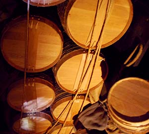
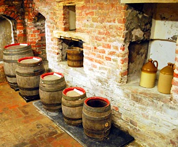
(above) A ship's cargo of barrels secured by ropes.
(below) Containers of different capacities on display in the cellar of the Corpus Christi
Guildhall, Lavenham; from left to right: a barrel (36 gallons), a kilderkin (8 gallons),
a firkin (9 gallons), and a pin (4.5 gallons). At an early period barrel sizes seem
to have varied from region to region, but this was something borough authorities tried
to standardize. The gild would have stored wine here for its feasts; the wall niches
now displaying smaller containers (jugs and bucket) would have served to keep off
the damp cellar floor items needing to be kept dry.
Photos © S. Alsford
